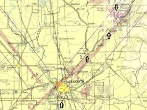
This is a scan from the January 1946 Sacramento sectional chart that depicts a number of interesting facets of how air navigation has evolved. This time around, we’ll look at the first development of long range airway navigation. A close examination of the chart reveals that the original lighted airway installed in the mid-1920s as the first transcontinental airway from San Francisco to Chicago was still in use in 1946. It provided point-to-point night time navigation along a course made up of airway beacons. The standard airway beacon consisted of a 1 million candlepower rotating beacon light providing omnidirectional visual identification, and also narrow-beam course lights aligned with the airway courses. This lighting combination was installed on the top of 51 foot towers that were themselves attached to 70-foot long concrete slab arrows aligned with the airway and painted with black and yellow markings for daytime use. The airway beacons were installed approximately every ten miles along the airway, and each set of course lights blinked a code that identified the individual airway beacon as marked on the chart. Every thirty miles or so the Civil Aeronautics Administration (CAA) built an “Intermediate Landing Field” for airway users. Looking at the chart, you can see the airway beacon installed at what is now Sacramento Executive Airport. Heading east, the next airway beacon (Beacon 8) was near Roseville. This beacon was actually located just northeast of the current intersection at Baseline and Foothills Road at what is now a school site. The next airway beacon was Beacon 9 installed just west of Newcastle (somewhat obscured on the chart). Airway Beacon 10 was at the Auburn airport, a CAA intermediate field. The airway continued east over Donner Pass, with beacons near Colfax, Alta, Blue Canyon, and Soda Springs. Blue Canyon and Truckee were also originally built as CAA intermediate airfields.
Next time: more airway history in the Sacramento area