by Scott Thompson
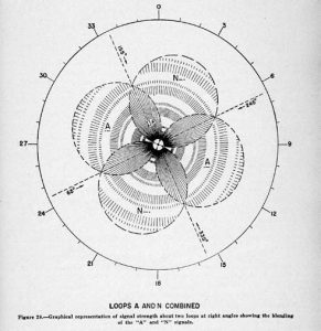 At left is a graphic suggesting the theoretical radiation pattern of the four-course ranges set up by the Bureau of Air Commerce and the later CAA. The four courses produced by the transmitters could be adjusted in azimuth by changing the relative power of the output. This allowed rudimentary airways to be developed that could interconnect and provide a measure of enroute navigation. It was not particularly accurate and it was difficult for pilots to master, but the four-course ranges provided the first practical method of air navigation when operating solely by aircraft instruments. (CAA)
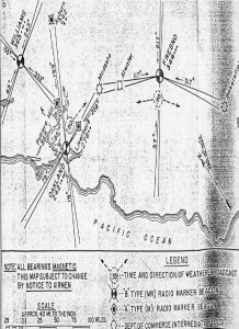
Below is an 1934 Bureau of Air Commerce Radio Facility Map depicting the four course ranges installed at Williams, Oakland, and Fresno. As the chart indicates, radio marker beacons were also installed at the range sites to aid in knowing when station passage occurred. These ranges transmitted in the low/medium frequency range and thus subject to predictable interference from weather and other anomalies. (CAA)